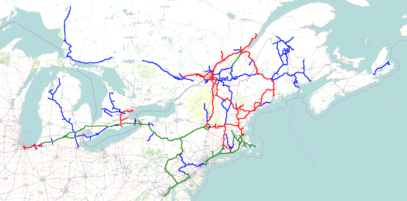
This shows the Parsons Vale system as it stood in the 2020s (after picking up a lot of lines in the mid-late 1990s and undergoing a slow electrification spree.) The system is about 14,000 route-kilometers long, ~7100 of which is under wire.
~4100 km of the electrification (shown in red) is various DC tensions (3000 volts on the original PV&T & TdM electrification, plus D&H north, the LT&L’s North Shore (of the Saint-Laurent) & the LT&L-B&Q-BAR international line from Québec to Bangor, ME; 1500 volts on the CSS&SB & ORRC’s lines, 600 volts on the Narragansett Pier, the Atlantic Shore, and the NStC&T’s Lakeshore running track), and the remainder (in green) is electrified at legacy AC tensions or 25kv.
The bulk of the AC electrification is D&H south & the D&H-OSW-CSS&SB electrification from Schenectady to Niles, Michigan; the remainder is the SLR, Old Colony & trackage rights on the NE Corridor, P&W, and the 25KVAC high speed section of the LT&L’s Victoria Air Line.
There are also 6 backshops, one which is also a locomotive builder:
The TdM shops in St-Jean-Sur-Richelieu, Québec are the primary shops for all of the Alcos & ILWs on the system.
the Portland shops – in the suburb of Westbrook – are the primary maintenance shop (and, at least since 1960, builder) for the large fleet of motors that operate the electrified regions.
Derby (Milo, Maine) is the EMD base; the BAR has long been an EMD stronghold, so all of the inherited EMDs on the system are based there. This is less ridiculous than it seems, because the Parsons Vale has a strong institutional preference for the lugging ability of the 251, and the TdM Shops complains bitterly whenever anything else (other than an ILW-built unit) clutters up the roster, so any EMD is transferred to the BAR and sent down east.
Colonie used to be the major backshop for the Delaware & Hudson, but it had fallen into disrepair when the D&H was purchased in 1984. It only came back into full operation when the D&H South electrification started, and it now does everything except catastrophic repairs for the AC motors on D&H South.
Guelph (Guelph, Ontario) is the old main shop for the TSR/ORRC, and does routine maintenance for the ORRC’s fleet of motors and the OSW’s fleet of diesels and dual-power units.
The CSS&SB’s old Michigan City shops are still in operation as the South Shore’s main shops, as well as supporting the NICTD’s large fleet of interurban cars & the I&M’s smallish fleet of diesel-electrics.